Sensoriamento remoto aplicado para estimar o coeficiente de cultivo e detectar mudanças na cobertura florestal
Resumo
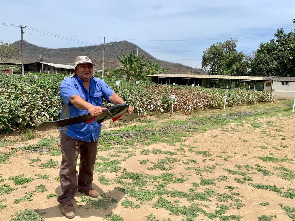
Com o objetivo de aplicar técnicas de sensoriamento remoto para a estimativa do coeficiente de culturas e a detecção de mudanças na cobertura florestal, a fim de gerar informações que contribuam para o gerenciamento sustentável dos recursos agrícolas e florestais, foi realizado um estudo com base nos fundamentos teóricos da agricultura 4.0, por meio da implementação de tecnologias avançadas e da integração inteligente de dados para otimizar todo o ciclo de produção agrícola. A metodologia adotada inclui a captura e o processamento de imagens multiespectrais de plataformas de satélite e veículos aéreos não tripulados (VANTs), a fim de obter informações geométricas e espectrais de várias culturas. Os cálculos dos índices espectrais (NDVI, NDMI, NDWI, Kc) e a análise das perdas de povoamentos florestais foram realizados por meio de ferramentas de software avançadas em um ambiente de SIG e na plataforma Google Earth Engine. As imagens de drones permitiram que o NDWI fosse calculado para classificar a umidade do solo em níveis altos, moderados e baixos. As imagens de satélite facilitaram a identificação das relações entre o coeficiente de evaporação da cultura (Kc) e os parâmetros climáticos, bem como a detecção de áreas com perda de floresta na bacia do rio Carrizal. Os resultados sugerem estratégias para o desenvolvimento de atividades de agricultura de precisão, promovendo a substituição de práticas convencionais por mecanismos de desenvolvimento sustentável baseados em tecnologias geoespaciais. Este estudo contribui para a literatura ao demonstrar a aplicação de tecnologias geoespaciais avançadas para otimizar a produção agrícola e a sustentabilidade.
Downloads
Referências
Basharat, U., Tariq, S., Chaudhry, M. N., Khan, M., Agyekum, E. B., Mbasso, W. F., & Kamel, S. (2023). Seasonal correlation of aerosols with soil moisture, evapotranspiration, and vegetation over Pakistan using remote sensing. Heliyon, 9(10). https://doi.org/10.1016/j.heliyon.2023.e12521
Chandramohan, K., Elayapillai, P., Vijayalakshmi, G., & Kaliraj, S. (2024). Evaluating the relation of NDVI, NDWI, SMI, and LAI to land and soil degradation processes—a case study of Virudhunagar district, Tamil Nadu, India. In Remote Sensing of Soils (pp. 689-697). Elsevier. https://doi.org/10.1016/B978-0-12-821598-5.00043-7
Chen, J. M., & Liu, J. (2020). Evolution of evapotranspiration models using thermal and shortwave remote sensing data. Remote Sensing of Environment, 237, 111594. https://doi.org/10.1016/j.rse.2019.111594
Das, S., Sharma, N., Sharma, P., & Kushwaha, N. L. (2023). Assessment of rainfall (R), evapotranspiration (ET), and crop coefficient (Kc) using satellite data. In Surface and Groundwater Resources Development and Management in Semi-arid Region: Strategies and Solutions for Sustainable Water Management (pp. 365-380). Springer International Publishing. https://doi.org/10.1007/978-3-030-51754-8_20
Datta, P., & Faroughi, S. A. (2023). A multihead LSTM technique for prognostic prediction of soil moisture. Geoderma, 433, 116452. https://doi.org/10.1016/j.geoderma.2022.116452
De La Guardia, L., de Miranda, J. H., & dos Santos Luciano, A. (2024). Assessment of irrigation water use for dry beans in center pivots using Era5 land climate variables and Sentinel-2 NDVI time series in the Brazilian Cerrado. SSRN. https://doi.org/10.2139/ssrn.4917244
Del Valle, T. M., & Jiang, P. (2022). Comparison of common classification strategies for large-scale vegetation mapping over the Google Earth Engine platform. International Journal of Applied Earth Observation and Geoinformation, 115, 103092. https://doi.org/10.1016/j.jag.2022.103092
Eliades, M., Bruggeman, A., Djuma, H., Christofi, C., & Kuells, C. (2022). Quantifying evapotranspiration and drainage losses in a semi-arid nectarine (Prunus persica var. nucipersica) field with a dynamic crop coefficient (Kc) derived from leaf area index measurements. Water, 14(5), 734. https://doi.org/10.3390/w14050734
Elogne, A. G., Piponiot, C., Zo-Bi, I. C., Amani, B. H., Van der Meersch, V., & Hérault, B. (2023). Life after fire—Long-term responses of 20 timber species in semi-deciduous forests of West Africa. Forest Ecology and Management, 538, 120977. https://doi.org/10.1016/j.foreco.2023.120977
Fuentes-Peñailillo, F., Gutter, K., Vega, R., & Silva, G. C. (2024). Transformative technologies in digital agriculture: Leveraging Internet of Things, remote sensing, and artificial intelligence for smart crop management. Journal of Sensor and Actuator Networks, 13(4), 39. https://doi.org/10.3390/jsan13040039
Ge, X., Ding, J., Jin, X., Wang, J., Chen, X., Li, X., & Xie, B. (2021). Estimating agricultural soil moisture content through UAV-based hyperspectral images in the arid region. Remote Sensing, 13(8), 1562. https://doi.org/10.3390/rs13081562
Judge, J., Liu, P. W., Monsiváis-Huertero, A., Bongiovanni, T., Chakrabarti, S., Steele-Dunne, S. C., & Cosh, M. (2021). Impact of vegetation water content information on soil moisture retrievals in agricultural regions: An analysis based on the SMAPVEX16-MicroWEX dataset. Remote Sensing of Environment, 265, 112623. https://doi.org/10.1016/j.rse.2021.112623
Ippolito, M., De Caro, D., Ciraolo, G., Minacapilli, M., & Provenzano, G. (2023). Estimating crop coefficients and actual evapotranspiration in citrus orchards with sporadic cover weeds based on ground and remote sensing data. Irrigation Science, 41(1), 5-22. https://doi.org/10.1007/s00271-022-00829-4
Karunathilake, E. M. B. M., Le, A. T., Heo, S., Chung, Y. S., & Mansoor, S. (2023). The path to smart farming: Innovations and opportunities in precision agriculture. Agriculture, 13(8), 1593. https://doi.org/10.3390/agriculture13081593
Kganyago, M., Adjorlolo, C., Mhangara, P., & Tsoeleng, L. (2024). Optical remote sensing of crop biophysical and biochemical parameters: An overview of advances in sensor technologies and machine learning algorithms for precision agriculture. Computers and Electronics in Agriculture, 218, 108730. https://doi.org/10.1016/j.compag.2024.108730
Khose, S. B., & Mailapalli, D. R. (2024). Spatial mapping of soil moisture content using very-high resolution UAV-based multispectral image analytics. Smart Agricultural Technology, 8, 100467. https://doi.org/10.1016/j.sat.2024.100467
Kumari, A., Singh, J., & Gupta, H. (2024). Multi-temporal analysis of vegetation extent using Google Earth Engine. In Natural Resource Monitoring, Planning and Management Based on Advanced Programming (pp. 29-45). Springer Nature Singapore. https://doi.org/10.1007/978-981-99-0643-5_2
Lemesios, I., & Petropoulos, G. P. (2024). Vegetation regeneration dynamics of a natural Mediterranean ecosystem following a wildfire exploiting the LANDSAT archive, Google Earth Engine, and geospatial analysis techniques. Remote Sensing Applications: Society and Environment, 34, 101153. https://doi.org/10.1016/j.rsase.2024.101153
Lobos, G., Veas, A., Balbontín, C., Muñoz, V., Franck, N., & Portilla, Á. (2017). Manejo hídrico en frutales bajo condiciones edafoclimáticas de Limarí y Choapa. Boletin INIA N° 355. Instituto de Investigaciones Agropecuarias de Chile. https://hdl.handle.net/20.500.14001/6619
Mc Feeters, S. K. (1996). The use of the Normalized Difference Water Index (NDWI) in the delineation of open water features. International Journal of Remote Sensing, 17 (7): 1425-1432. https://doi.org/10.1080/01431169608948714
Manfreda, S., & Dor, E. B. (2023). Remote sensing of the environment using unmanned aerial systems. In Unmanned Aerial Systems for Monitoring Soil, Vegetation, and Riverine Environments (pp. 3-36). https://doi.org/10.1201/9780367334232-1
Masi, M., Di Pasquale, J., Vecchio, Y., & Capitanio, F. (2023). Precision farming: Barriers of variable rate technology adoption in Italy. Land, 12(5), 1084. https://doi.org/10.3390/land12051084
Mehedi, I. M., Hanif, M. S., Bilal, M., Vellingiri, M. T., & Palaniswamy, T. (2024). Remote sensing and decision support system applications in precision agriculture: Challenges and possibilities. IEEE Access. https://doi.org/10.1109/ACCESS.2024.1234567
Munaganuri, R. K., & Yamarthi, N. R. (2024). PAMICRM: Improving precision agriculture through multimodal image analysis for crop water requirement estimation using multidomain remote sensing data samples. IEEE Access. https://doi.org/10.1109/ACCESS.2024.1234568
Pedroza-Parga, E., Velásquez-Valle, M. A., Pedroza-Sandoval, A., Sánchez-Cohen, I., & Yáñez-Chávez, L. G. (2022). The impact of vegetation cover on soil erosion and soil deposition due to runoff. Ingeniería agrícola y biosistemas, 14(1), 17-31. https://doi.org/10.5154/r.inagbi.2021.12.135
Terink, W., Lutz, A. F., Simons, G. W. H., Immerzeel, W. W., & Droogers, P. (2015). SPHY v2. 0: Spatial processes in hydrology. Geoscientific Model Development, 8(7), 2009-2034. https://doi.org/10.5194/gmd-8-2009-2015
Toosi, A., Javan, F. D., Samadzadegan, F., Mehravar, S., Kurban, A., & Azadi, H. (2022). Citrus orchard mapping in Juybar, Iran: Analysis of NDVI time series and feature fusion of multi-source satellite imageries. Ecological Informatics, 70, 101733. https://doi.org/10.1016/j.ecoinf.2022.101733
Sabie, R., Bawazir, A. S., Buenemann, M., Steele, C., & Fernald, A. (2024). Calculating Vegetation Index-Based Crop Coefficients for Alfalfa in the Mesilla Valley, New Mexico Using Harmonized Landsat Sentinel-2 (HLS) Data and Eddy Covariance Flux Tower Data. Remote Sensing, 16(16), 2876. https://doi.org/10.3390/rs16162876
Yi, W., Wang, N., Yu, H., Jiang, Y., Zhang, D., Li, X., & Xie, Z. (2024). An enhanced monitoring method for spatio-temporal dynamics of salt marsh vegetation using google earth engine. Estuarine, Coastal and Shelf Science, 298, 108658. https://doi.org/10.1016/j.ecss.2024.108658
Wu, Z., Cui, N., Zhang, W., Yang, Y., Gong, D., Liu, Q., & Zhu, B. (2024). Estimation of soil moisture in drip-irrigated citrus orchards using multi-modal UAV remote sensing. Agricultural Water Management, 302, 108972. https://doi.org/10.1016/j.agwat.2024.108972
Direitos de Autor (c) 2025 Henry Antonio Pacheco Gil, Cristhian Martin Delgado Marcillo, Roger Adrián Delgado Alcívar, Luis Fernando Fernández Zambrano, Néstor Erick Caal Suc, Emilio José Jarre Castro

This work is licensed under a Creative Commons Attribution-NonCommercial-ShareAlike 4.0 International License.