Fatores relativos à variabilidade espacial do carbono orgânico do solo em uma pequena bacia hidrográfica Mexican
Resumo
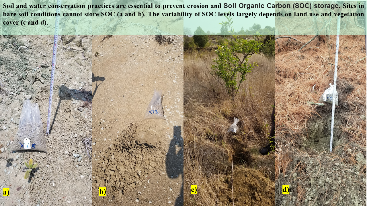
Compreender os stocks de Carbono Orgânico do Solo (COS) e elucidar as variáveis que influenciam a sua distribuição espacial dentro de uma pequena bacia hidrográfica são imperativos para o avanço de estratégias específicas de mitigação das alterações climáticas, especificamente dirigidas à conservação do solo e da água. A seleção desta bacia hidrográfica baseia-se na implementação, ao longo de três décadas, de diversas práticas de conservação do solo e da água. Portanto, o objetivo deste estudo foi analisar o uso do solo, a cobertura vegetal, a declividade e as práticas de conservação do solo e da água (SCWP) como fatores que influenciam a variabilidade e a distribuição espacial do carbono orgânico do solo em uma pequena bacia na região de Mixteca Alta do estado de Oaxaca. México. Amostras de solo (77) foram coletadas para determinar o armazenamento de SOC. Essas amostras foram interpoladas usando o plugin QGIS Smart-Map para obter um modelo preditivo espacial de COS. Foram gerados mapas temáticos para cada fator. Estatísticas de área, correlação de Pearson e análise de componentes principais (ACP) foram realizadas para explicar a variabilidade do COS. Os resultados na variabilidade do SOC em relação à cobertura vegetal e uso do solo, mostraram as plantações de pinus adulto com o maior valor de SOC com 36,8 t.ha-1, seguidas pela agricultura sazonal com 28,8 t.ha-1. A prática de manejo mais eficaz para armazenamento de COS foi o terraço de pedra com 35,0 t.ha-1. Nossos resultados indicam que a cobertura vegetal e o uso da terra complementados por práticas de conservação do solo e da água são os principais impulsionadores do armazenamento de SOC em pequenas bacias hidrográficas.
Downloads
Referências
Bingfang, W., &Qiangzi, L. (2004). Crop area estimation using remote sensing on two-stage stratified sampling. International Society for Photogrammetry and Remote Sensing (ISPRS), 20, 12-23.https://bit.ly/3SVuXYb
Borůvka, L., Vašát, R., Šrámek, V., Hellebrandová, K. N., Fadrhonsová, V., Sáňka, M., Pavlů, L., Sáňka, O., Vacek, O., Němeček, K., Nozari, S., & Sarkodie, V. Y. O. (2022). Predictors for digital mapping of forest soil organic carbon stocks in different types of landscape. Soil and Water Research, 17(2), 69–79. https://doi.org/10.17221/4/2022-SWR
Boubehziz, S., Khanchoul, K., Benslama, M., Benslama, A., Marchetti, A., Francaviglia, R., &Piccini, C. (2020). Predictive mapping of soil organic carbon in Northeast Algeria. Catena, 190. https://doi.org/10.1016/J.CATENA.2020.104539
Cotler, H., Cram, S., Martínez Trinidad, S., & Bunge, V. (2015). Conservation practices assessment in forest soils of Mexico: The case of the ditches. Investigacionesgeográficas, (88), 6-18.https://doi.org/10.14350/rig.47378
De Gruijter, J., Brus, D. J., Bierkens, M. F., &Knotters, M. (2006). Sampling for Natural Resource Monitoring. Sampling for Natural Resource Monitoring. https://doi.org/10.1007/3-540-33161-1
Figueroa Jáuregui, M. D. L., Martínez Menez, M. R., Ortiz Solorio, C. A., & Fernández Reynoso, D. (2018): Influence of forming factors on soil properties in the Mixteca, Oaxaca, Mexico. Terra Latinoamericana, 36(3): 287–299.https://doi.org/10.28940/terra.v36i3.259
Gadisa, S., &Hailu, L. (2020). Effect of Level Soil Bund and FaynaJuu on soil physico-chemical properties, and farmers adoption towards the practice at Dale Wabera district, western Ethiopia. American Journal of Environmental Protection, 9(5): 107–20.https://doi.org/10.11648/j.ajep.20200905.12
Jahn, R., Blume, H. P., Asio, V. B., Spaargaren, O., Schad, P. (2006). Guidelines for soil description. FAO: 9–12. Recovered from: https://www.fao.org/3/a0541e/a0541e.pdf
INEGI, National Institute of Statistics and Geography. (2017a). Continuum of Mexican Elevations 3.0 (CEM 3.0). Recoveredfrom:https://www.inegi.org.mx/app/geo2/elevacionesmex/
IPCC, 2021: Summary for Policymakers. In: Climate Change 2021: The Physical Science Basis. Contribution of Working Group I to the Sixth Assessment Report of the Intergovernmental Panel on Climate Change. Cambridge University Press, Cambridge, United Kingdom and New York, NY, USA, pp. 3−32. Recovered from: https://bit.ly/47BPype
Lal, R., Monger, C., Nave, L., & Smith, P. (2021). The role of soil in regulation of climate. Philosophical Transactions of the Royal Society B, 376(1834), 20210084.https://doi.org/10.1098/rstb.2021.0084
Lefèvre, C., Rekik, F., Alcantara, V., &Wiese, L. (2017).Soil organic carbon: the hidden potential.Food and Agriculture Organization of the United Nations. Rome, Italy. FAO: 1–7. Recovered from: https://www.fao.org/3/i6937e/i6937e.pdf
Leroux, L., Congedo, L., Bellón, B., Gaetano, R., &Bégué, A. (2018): Land Cover Mapping Using Sentinel-2 Images and the Semi-Automatic Classification Plugin: A Northern Burkina Faso Case Study. QGIS and Applications in Agriculture and Forest, 2: 119–151.https://doi.org/10.1002/9781119457107.ch4
Mekonnen, M., &Getahun, M. (2020): Soil conservation practices contribution in trapping sediment and soil organic carbon, Minizr watershed, northwest highlands of Ethiopia. Journal of Soils and Sediments, 20(5): 2484–2494.
https://doi.org/10.1007/s11368-020-02611-5
Nabiollahi, K., Shahlaee, S., Zahedi, S., Taghizadeh-Mehrjardi, R., Kerry, R., & Scholten, T. (2021): Land Use and Soil Organic Carbon Stocks—Change Detection over Time Using Digital Soil Assessment: A Case Study from Kamyaran Region, Iran (1988–2018). Agronomy 2021, Vol. 11: 597–597.https://doi.org/10.3390/AGRONOMY11030597
Ose, K. (2018). Introduction to GDAL Tools in QGIS. QGIS and generic tools, Vol. 1: 19–65.https://doi.org/10.1002/9781119457091.ch2
Paz Pellat, F., Argumedo Espinoza, J., Cruz Gaistardo, C. O., Etchevers, J. D., & de Jong, B. (2016): Spatial and temporal distribution of soil organic carbon in terrestrial ecosystems in Mexico.Terra Latinoamericana, 34(3): 289–310.https://www.scielo.org.mx/pdf/tl/v34n3/2395-8030-tl-34-03-00289.pdf
Penman, J., Gytarsky, M., Hiraishi, T., Krug, T., Kruger, D., Pipatti, R.,Buendia, L., Miwa, K.,Ngara, T., Tanabe, k., and Wagner, F. (2003).Good practice guidance for land use, land-use change and forestry. Institute for Global Environmental Strategies (IGES) for the IPCC, Japan: 3.42–3.43. https://bit.ly/49TLAcL
Pereira, G. W., Valente, D. S. M., Queiroz, D. M. de, Coelho, A. L. de F., Costa, M. M., & Grift, T. (2022): Smart-Map: An Open-Source QGIS Plugin for Digital Mapping Using Machine Learning Techniques and Ordinary Kriging. Agronomy 2022, Vol. 12: 1350–1350. https://doi.org/10.3390/AGRONOMY12061350
Walkley, A. & Black, C.A., 1934, An examination of the Degtjareff method for determining soil organic matter and a proposed modification of chromic acid titration method: Soil Science, 37, 29–38.https://bit.ly/3sNZEUJ
Wang, L., Li, Z., Wang, D., Liao, S., Nie, X., & Liu, Y. (2022): Factors controlling soil organic carbon with depth at the basin scale. CATENA, 217: 106478–106478. https://doi.org/10.1016/j.catena.2022.106478
Wiesmeier, M., Urbanski, L., Hobley, E., Lang, B., von Lützow, M., Marin-Spiotta, E., Kögel-Knabner, I. (2019). Soil organic carbon storage as a key function of soils-A review of drivers and indicators at various scales. Geoderma, 333: 149-162.https://doi.org/10.1016/j.geoderma.2018.07.026
Yescas-Coronado, P., Álvarez-Reyna, V. de P., Segura-Castruita, M. Á., García-Carrillo, M., Hernández-Hernández, V., & González-Cervantes, G. (2018): Spatial variability of organic and inorganic carbon in the soil in the Comarca Lagunera, Mexico.Bulletin of the Mexican Geological Society, 70(3): 591–610. https://doi.org/10.18268/BSGM2018V70N3A2
Direitos de Autor (c) 2024 Olimpya Talya Aguirre-Salado, Joel Pérez-Nieto, Carlos Arturo Aguirre-Salado, Alejandro IsmaelMonterroso-Rivas

This work is licensed under a Creative Commons Attribution-NonCommercial-ShareAlike 4.0 International License.