Transformação Afin Bidimensional (AT2D) para Interpolação de Velocidades Geodésicas utilizando Soluções Semanais SIRGAS-CON
Resumo
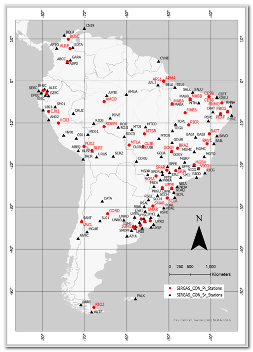
Os modelos de velocidade geodésica são cruciais para a transformação de coordenadas de uma época de referência para uma época de observação. Seu desenvolvimento costuma ser demorado e requer atualizações frequentes para manter sua validade. Para abordar a questão da validade, este estudo examina o uso da Transformação Afim Bidimensional (AT2D) para interpolar velocidades em estações GNSS na América do Sul. A AT2D baseia-se na triangulação a partir de estações SIRGAS-CON vizinhas com velocidades conhecidas em um intervalo de tempo específico. As velocidades resultantes do método AT2D e dos modelos VEMOS, em cinquenta estações, foram comparadas com suas velocidades conhecidas, permitindo cálculos residuais para avaliação da qualidade. Em 82% das comparações, a AT2D apresentou um RMSE menor (±1,4 mm/ano) do que os modelos VEMOS (±3,6 mm/ano). Os resultados mostram que o método AT2D reproduz efetivamente as velocidades SIRGAS-CON quando as estações estão localizadas na mesma placa tectônica. O AT2D oferece flexibilidade temporal que permite ajustes em resposta a saltos abruptos ou descontinuidades nos dados GNSS. Além disso, o AT2D é eficiente e preciso para calcular velocidades atualizadas em contextos locais ou regionais relevantes para topografia e engenharia geodésica.
Downloads
Referências
Bevis, M., Brown, A. (2014). Trajectory models and reference frames for crustal motion geodesy. Journal of Geodesy. Volume 88, pages 283–311. doi: 10.1007/s00190-013-0685-5.
Drewes, H., Heidbach, O. (2005). Deformation of the South American crust estimated from finite element and collocation methods', in Sansò, F. (ed.). A Window on the Future of Geodesy. IAG Symposia, vol. 128, pp. 544–549. Springer, Berlin, Heidelberg. doi: 10.1007/3-540-27432-4_92.
Drewes, H. (2020). Modelar el movimiento de la superficie terrestre. Velocidades continuas y coordenadas por etapas. Technische Universität München (TUM), International Association of Geodesy (IAG), Sistema de Referencia Geodésico para las Americas (SIRGAS). Webinar SIRGAS, 28 August 2020. Available at: www.sirgas.ipgh.org/docs/Boletines/2020_Drewes_Webinar_VEMOS.pdf.
Drewes, H., Sánchez, L. (2020). Velocity model for SIRGAS 2017: VEMOS2017. PANGAEA. Technische Universität München, Deutsches Geodätisches Forschungsinstitut (DGFI-TUM), IGS RNAAC SIRGAS. [Online]. doi: 10.1594/PANGAEA.912350.
Drewes, H., Seitz, M., Sánchez, L. (2024). Realisation of the Non-Rotating Terrestrial Reference Frame by an Actual Plate Kinematic and Crustal Deformation Model (APKIM2020). International Association of Geodesy Symposia. Springer, Berlin, Heidelberg. doi:10.1007/1345_2024_276.
Feder, J. (1988). The Perimeter-Area Relation. Fractals: Physics of Solids and Liquids. Springer, Boston, MA. doi:10.1007/978-1-4899-2124-6_12.
Ghilani, C. (2018). Adjustment Computations: Spatial Data Analysis. 6th edn. John Wiley & Sons, Inc. Hoboken, New Jersey.
Gómez, D., Piñón, D., Smalley, R., Bevis, M., Cimbaro, S., Lenzano, L., Barón, J. (2016). Reference frame access under the effects of great earthquakes: a least squares collocation approach for non-secular post-seismic evolution. Journal of Geodesy, Volume 90, Issue 3, pp. 263-273. DOI:10.1007/s00190-015-0871-8.
Harris, C., Millman, K., van der Walt, S., Gommers, R., Virtanen, P., Cournapeau, D., Wieser, E., Taylor, J., Berg, S., Smith, N., Kern, R., Picus, M., Hoyer, S., Kerkwijk, M., Brett, M., Haldane, A., Fernández del Río, J., Wiebe, M., Peterson, P., Oliphant, T. (2020). Array programming with NumPy. Nature 585(7825), pp. 357–362. doi:10.1038/s41586-020-2649-2.
Hoyer, M., Arciniegas, S., Pereira, K., Fagard, H., Maturana, R., Torchetti, R., Drewes, H., Kumar, M., Seeber, G. (1998). The Definition and Realization of the Reference System in the SIRGAS Project', in Brunner, F.K. (ed.). Advances in Positioning and Reference Frames. International Association of Geodesy Symposia, vol. 118. Springer, Berlin, Heidelberg.
Lay, D., Lay, S., McDonald, J. (2016). Linear Algebra and Its Applications. 5th edn. Pearson.
Li, Z., Zhu, C., Gold, C., Wu, H., Fritsch, D. (2005). Digital Terrain Modeling: Principles and Methodology. CRC Press.
Sánchez, L. (2023). SIRGAS Regional Network Associate Analysis Centre, Technical Report 2022. IGS Technical Report 2022. doi:10.48350/179297.
Sánchez, L. Drewes, H. (2020). Geodetic monitoring of the variable surface deformation in Latin America. International Association of Geodesy Symposia Series, vol. 152. Springer, Cham. doi: 10.1007/1345_2020_91
Sánchez, L., Drewes, H., Kehm, A., Seitz, M. (2022). SIRGAS reference frame analysis at DGFI-TUM. Journal of Geodetic Science, 12(1), pp. 92–119. doi:0.1515/jogs-2022-0138.
SIRGAS Analysis Centre at DGFI-TUM. (2024a). SIRGAS continuously operating network. Available at: www.sirgas.org/en/sirgas-realizations/sirgas-con-network/.
SIRGAS Analysis Centre at DGFI-TUM. (2024b). SIRGAS continuously operating stations. Available at: www.sirgas.org/en/stations/station-list/.
SIRGAS Analysis Centre at DGFI-TUM. (2024c). VEMOS: Velocity model for SIRGAS. Available at: www.sirgas.org/en/velocity-model/.
Suárez, H. (2023). SIGGMA GEODETIC CALCULATOR – SGC. Sociedad de Ingenieros Geodestas, Geomáticos y Agrimensores de Venezuela – SIGGMA. Available at: www.siggma.xyz/sgc/.
Suárez, H., Arenas, I., Cano, N., Marcano, P., Diaz, M., Martínez, A. (2024). Local TIN Interpolation (LTI) for the calculation of horizontal velocity components, based on weekly time series from SIRGAS-CON stations. Sistema de Referencia Geodésico para las Américas (SIRGAS). Simposio SIRGAS 2024, Bogotá, Colombia, 18-21 de noviembre de 2024.
Yan, Y., Li, M., Dai, L., Guo, J., Dai, H., Tang, W. (2022). Construction of “Space-Sky-Ground” Integrated Collaborative Monitoring Framework for Surface Deformation in Mining Area. Remote Sensing, 14, 840. doi: 10.3390/rs14040840.
Direitos de Autor (c) 2025 Hermógenes David Suárez Acosta, Ileanis del Carmen Arenas Bermúdez, Nilbeny Nibraska Cano Finol, Paola Chiquinquirá Marcano Márquez, Alisleidy Paola Martínez Martínez

This work is licensed under a Creative Commons Attribution-NonCommercial-ShareAlike 4.0 International License.
Copyright
La Revista Técnica de la Facultad de Ingeniería declara que los derechos de autor de los trabajos originales publicados, corresponden y son propiedad intelectual de sus autores. Los autores preservan sus derechos de autoría y publicación sin restricciones, según la licencia pública internacional no comercial ShareAlike 4.0


_2.04__.27_p__._m__.__.png)