Comparison of Geomechanical Models obtained from DInSAR with existing model generated from well logs for the Lower Lagunillas-07 (LGINF-07) Reservoir in Lake Maracaibo, Venezuela
Abstract
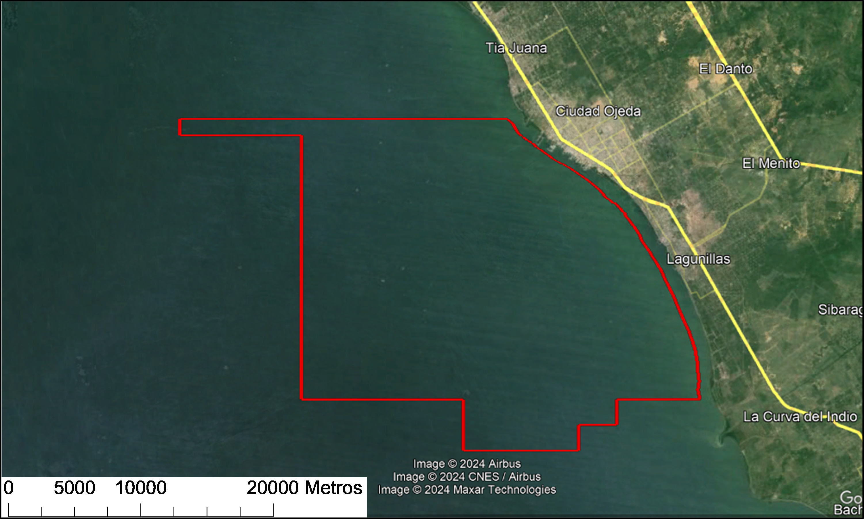
The LGINF-07 reservoir, located in the Lagunillas Lago field within the Lake Maracaibo basin, spans 200,000 m² and contains 18° API crude oil, accounting for 73% of the original oil in place (OOIP). Production-induced rock compaction has caused progressive surface subsidence. To enhance monitoring, the DInSAR technique was applied to all oil platforms, enabling comparisons between subsidence and production values in the most affected areas. The study aimed to compare the 1D geomechanical model obtained through DInSAR with the existing model based on well logs, incorporating recent petrophysical and sonic data as well as core sample characterization. Results revealed a normal stress regime (σV > σH > σh) and demonstrated that the updated model is more accurate than the previous correlation-based model. The integration of DInSAR with geomechanical parameters improved the identification of critical subsidence areas, highlighting AGUA-230, AGUA-241, and AGUA-242 as the most affected. This updated model enhances operational management and strategic decision-making, helping to mitigate the impact of subsidence on critical infrastructure and improving production efficiency
Downloads
References
Angarita, M., Graves, E., Grapenthin R., Grigg, J., Rinehart, A. (2023). InSAR-observed surface deformation in New Mexico’s Permian Basin shows threats and opportunities presented by leaky injection Wells. Scientist report of Nature, 17308.
Arenas, I., (2018) Cuantificación de la subsidencia de la costa oriental del lago de Maracaibo a través de interferometría diferencial con radar de apertura sintética. Tesis de Grado. Universidad del Zulia. Facultad de Ingeniería. División de Postgrado. Maracaibo, Venezuela, 46-47.
Barrios, J. González, D. Zambrano, O. (2016). Comparación del modelo geomecánico del yacimiento Lagunillas Inferior 07 con el modelo petrofísico para explicar el fenómeno de subsidencia Tesis de Grado. Universidad del Zulia. Facultad de Ingeniería. División de Postgrado. Maracaibo, Venezuela, 112-127.
Barrios, J., Sanchez, E. (2013). Manual de Geomecánica aplicada a la Industria Petrolera. PDVSA-Intevep, Venezuela. Sección 3, 1-34.
Bevc, D., Mali, G., Milliken, W., Nihei, K., Shabelansky, A., Zhang, Z. (2022). Geomechanical Interferometry: Theory and Application to Time-Lapse Interferometric Synthetic Aperture Radar Data for Separating Displacement Signal Between Overburden and Reservoir Sources. Journal of SPE-OnePetro. SPE J. 27 (06): 3773–3782.
Briceño, L. (2009). Modelo estructural y estratigráfico basado en la interpretación sísmica 3D del yacimiento Lagunillas inferior LL07. Tesis de Grado. Universidad del Zulia. Facultad de Ingeniería. División de Postgrado. Maracaibo, Venezuela, 31-60.
Casu, F., Manzo, M., Lanari, R. (2006). A quantitative assessment of the SBAS algorithm performance for surface deformation retrieval from DInSAR data. Remote Sensing of Environment, 102(1-2), pp.195-210.
Chrzanowski, A. and Chen, Y. Q. (1991). Use of the Global Positioning System (GPS) for Ground Subsidence Measurements in Western Venezuela Oil Fields, Proceedings of the Fourth
International Symposium on Land Subsidence, No. 200, 419- 431.
Ferretti, A.; Prati, C., Rocca, F. (2001). “Permanent Scatterers in SAR Interferometry”, IEEE Transactions on Geoscience and Remote Sensing, 39, 8-20.
Fjær, E., Holt, R.M., Horsrud, P., Raaen, A.M. (2008). Petroleum Related Rock Mechanics, 2nd Edition. Elsevier. Amsterdam, The Netherlands, 391-426.
Gabriel, A.K., Goldstein, R.M., Zebker, H.A. (1989). Mapping small elevation changes over large areas: differential radar interferometry. Journal of Geophysical Research: Solid Earth, 94(B7), 9183-9191.
Geertsma, J. (1973). Land Subsidence above compacting oil and gas reservoirs. Journal of Petroleum Technology. No. 03730, 734-744.
He, J., Li, H., Misra, S. (2019). Data-Driven In-Situ Sonic-Log Synthesis in Shale Reservoirs for Geomechanical Characterization. Journal of SPE – OnePetro. Res Eval & Eng 22 (04): SPE-191400-PA, 1225–1239.
Leal, J. (1989). Integration of GPS and Leveling for Subsidence Monitoring Studies at Costa Bolivar Oil Fields, Venezuela. Technical Report No. 144, University of New Brunswick, 18-89.
Li, B., Khoshmanesh, M., Avouac Jean-Philippe. (2021). Surface Deformation and Seismicity Induced by Poroelastic Stress at the Raft River Geothermal Field, Idaho, USA. Geophysical Research Letters, 48, e2021GL095108. https://doi.org/10.1029/2021GL095108, 4-9.
Liu, G., Tong, J., Wang, X., Xiang, W., Yuan, H., Zhang, C., Zhang, R., Zhang, X., Zhang, Y. (2023). Geodetic imaging of ground deformation and reservoir parameters at the Yangbajing Geothermal Field, Tibet, China. Geophysical Journal International, 279-394.
Lundgren, P., Usai, S., Sansosti, R., Lanari, R., Tesauro, M., Fornaro, G., y Berardino, P. (2001). “Modeling surface deformation observed with SAR Interferometry at Campei Flegrei Caldera”, J. Geophysical. Res., 106, 19355-19367.
Ju, X., Yang, J., Yang, Y., Xu, L. (2023) “Influence of geological factors on surface deformation due to hydrocarbon exploitation using time-series InSAR: A case study of Karamay Oilfield, China”, Journal of Frontiers in Earth Sciences. 10.3389/feart.2022.983155, 6-12.
Murria, J. (1991). Subsidence Due to Oil Production in Western Venezuela: Engineering Problems and Solutions. Proceedings of the Fourth International Symposium on Land Subsidence, No. 200, 129-139.
Murria, J. (2007). Ground Subsidence Measuring, Monitoring and Modeling in the Costa Oriental Oilfields in Western Venezuela: The Last Fifty Years, 8th International Conference “Waste Management, Environment Geotechnology and Global Sustainable Development (ICWMEGGSD’07-GzO’07)”, 337-372.
Teatini, P., Comola, F., Janna, C. (2013). Reservoir uncertainties resolved via Global Optimization Strategies coupling SAR interferometry and geomechanical modelling - The Tengiz case study. Offshore Mediterranean Conference & Exhibition 2013, 4-10.
Torres, L. (2009). Construcción del Modelo Geomecánico del Yacimiento Lagunillas Inferior 07. Tesis de Grado. Universidad del Zulia. Facultad de Ingeniería. División de Postgrado. Maracaibo, Venezuela, 78-88.
Pepe, A., Callo, F. (2017). A review of interferometric synthetic aperture RADAR (InSAR) multi-track approaches for the retrieval of Earth's surface displacements. Appl. Sci. 7 (12), 1264, 2-13.
Quintana, G. (2021). La interferometría SAR (Synthetic Aperture Radar) para el estudio de las deformaciones de la corteza, derivadas de la geodinámica. Ejemplos de aplicación: Kumamoto (Japón), Valencia y Costa Oriental del Lago de Maracaibo (Venezuela). Trabajo Final de Grado de Magister Scientiarum mención Ciencias Geológicas. Postgrado en Ciencias Geológicas, Universidad Central de Venezuela, 24-36.
Raspini, F. Caleca, F., Festa, D., Confuorto, P., Bianchini, F. (2022). Review of satellite radar interferometry for subsidence análisis. Earth Science Reviews. 10.1016/j.earscirev.2022.104239, 2-5.
Shirzaei, M., Mang, M., Zha, G. (2019). Hydraulic properties of injection formations constrained by surface deformation. Earth and Planetary Science Letters Vol 515, 125-134.
Usai, S. (2001). A new approach for long term monitoring of deformation by differential SAR interferometry”, Tesis Doctoral, Delft Univ. Press, Delft, Países Bajos, 7-22.
Vasco, D., Dixon, T., Ferreti, A., Samdonov, S. (2020) Monitoring the fate of injected CO2 using geodetic techniques. The Leading Edge Journal, Vol 39, #1. https://doi.org/10.1190/tle39010029.1, 30-36.
Walford, J. (1995). GPS Subsidence Study of The Costa Bolivar Oil Fields, Venezuela. Technical Report No. 174, University of New Brunswick, 1-11.
Zoback, M.D. (2010). Reservoirs Geomechanics. Cambridge University Press, 167-196.
Copyright
La Revista Técnica de la Facultad de Ingeniería declara que los derechos de autor de los trabajos originales publicados, corresponden y son propiedad intelectual de sus autores. Los autores preservan sus derechos de autoría y publicación sin restricciones, según la licencia pública internacional no comercial ShareAlike 4.0


_2.04__.27_p__._m__.__.png)